
There were two visits to Texas, one in late May the other in early July, and I am writing about both of them together. Each time we chose to drive because we seemed to “need” a longer road trip, along with a non-airport change in scenery. Our time in Texas was spent largely with my dad, in Sanger, and with one of my sisters, in Dallas, although we drive around parts of Denton more than once.
Because in the past I have documented a number of air trips to Dallas, I will refrain from my usual references to Whataburger and Chuy’s and focus on our observation regarding new (for us) stuff.  One of the the biggest changes was found in roadside signs; specifically, those related to the nationwide shift in laws regarding the legal status of marijuana consumption. The 1960s and 1970s references to reefer (and reefer madness), joints, doobies, pot, alligator cigarettes, weed, dirt weed, devil’s lettuce, grass, party parsley, mary, mary jane, hash, herb goofy boots, and bogarting take on a whole different meaning when rolling down the road at 80 mph or passing through a town and seeing signs such as:
- Weed Maps Guide to Cannabis – Learn, Order, Smile
- Lotus Gold Marijuana Dispensary
- Hempyz Smoke Shop
- Ivy League Cannabis
- The Main Street Dispensary (in Stillwater, Oklahoma)
- Stillwater Dispensary
- Flippen Farma
It’s hard for me not to laugh loudly when I see these signs, given that in the early 1970s in Texas simple possession (less than an ounce) could yield serious jail time, and a life permanently ruined. Yet today, there is a raging debate about legalization.  The September 2019 edition of AARP magazine has a picture of the evil weed on the cover with the title: Special Report, Marijuana and Your Health.
My grandmother Ersilia (we knew her as Elsie or Nan) would feel so much less embarrassed by her early consumption of the evil weed given society’s shift in opinions about smoking or otherwise ingesting the key element of this plant. Her toking took place before the 1937 Marijuana Tax Act became law, thus when she imbibed it was legal. I wonder what she called it. Too bad I never asked her.
The late May drive was marked by almost constant, and sometimes pounding, rain from about 50 miles north of Topeka to Paul’s Valley, Oklahoma, our stopping point for the night. Virtually every river we crossed was out of its banks, and on a few days prior to our drive Interstate 35 the 35 in west coast speak) was closed due to flooding. We saw the Arkansas River, Salt Fork, as well as the Chickaskie, Washita, and Ninnescah Rivers well above flood stage, water covering many acres of crop- and ranch-land. We had seen news reports about flooding around Wichita and Emporia, Kansas, but seeing it first hand provided a whole new layer to the images we had observed on TV. In addition, El Dorado Lake had gone well beyond its banks and had flooded the 35 just a few days before we drove that way. Even the Flint Hills, which has the most dense coverage of intact tallgrass prairie in the U.S. was flooded in spots. I have driven from Omaha to Dallas many times since 1984, often passing through the Flint Hills. I have never seen this area as green or as wet as we observed this time around.
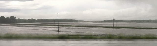 We took periodic notes (and pictures) regarding the weather and flooding. Here is a sample of our observations:
- Rain began near Holton, KS (it would rain for the next 380 miles)
- Kansas River at North Topeka is high, evidence of flooding
- 5:13 pm – weather alert for our area, flash flooding
- Mile marker (MM) 139—frog strangling rain, 10 miles north of Emporia, lots of lightening
- Neosho River out of its banks; yikes, we are hydroplaning
- Cottonwood River, well out of its banks, flooded fields in all directions
- Local flood traffic (sign), right lane
- High water when flashing (sign), it was flashing
- Car in the ditch at MM 108, young people involved, no one is hurt
- Car in the ditch at MM 106, no damage seen
- Raging water everywhere
- Worst rain yet at MM 83, cars pulling off, traffic at 30-40 mph (top speed)
- Car crash at MM 77
- White Water River out of its banks at MM 65, flooding everywhere
- Arkansas River is flooding, again fields are covered with water
- Just south of Wellington, Kansas, hard rain and lightening
- Major flooding 30 miles north of Perry, Oklahoma
- Arrive in Paul’s Valley, light rain
The Flint Hills stretches south from near the Kansas-Nebraska border to northern Oklahoma, over 200 miles. It is about 100 miles wide, covering cities such as Manhattan and Emporia, Kansas.
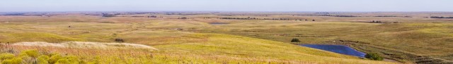 The drive through the hills provides a very pleasant break from the monotonous grey slab interstate ride, and is marked by gently rolling hills, endless horizons, tall grass that stretches forever, and rock outcrops that glisten (if there is enough light) because of the bands of chert that are contained in the limestone base. The land is no good for crops, the natives and others tried that, but excellent for grazing.
  Imagine, more than 160 years ago, millions of bison walking, trotting, or running across this immense area. The sight, and the sound of hoofbeats and grunting (bison are very loud and expressive animals) must have been amazing.
As noted above, we stopped in Paul’s Valley, Oklahoma, for the night (both trips), in part because we had a later departure from Omaha. Paul’s Valley is a very small town that has adjusted well to the completion of Interstate 35, 50 years ago. In the 1960s when I first drove with my parents south from Stillwater to Dallas, we traversed national highway 77, and moved right through Paul’s Valley. Back then, the traffic through this part of Oklahoma proceeded slowly, or very fast, and dangerously. The steep hills of the Arbuckle Mountains meant that the vehicle flow was either at 30 mph, the speed of an 18-wheel truck straining to get up a hill, or 75 plus mph as the trucks and passing cars careened down the hill, soon to be slowed again. I would close my eyes as this variable speed conga line of cars, buses, and trucks did this dangerous dance, again and again, especially when it was downhill and the road was curving. Today, the 35 skirts the town, yet business development along the interstate has kept the area economy relatively strong. And, the traffic goes 75 mph plus both up and down flattened out hills.
You can learn a lot about a place spending 30 or so minutes looking through the local newspaper. The Saturday-Sunday, July 6-7, edition of the Paul’s Valley Democrat was full of local stories that provided a good sense for the goings-on in the community. The lead story was about a new delivery service business started by a 23-year-old local. There were lessons on pest control (dried coffee grounds help control yard pests such as chiggers, ticks, and mold).  The world championship for watermelon seed spitting was held in Paul’s Valley on July 4—the story contained a less than complimentary photo of a middle-age woman with nice earrings and other jewelry letting one of those seeds fly from her mouth. There was an editorial arguing for an end to congressional gridlock. There was good coverage of education-related events: local students attended a STEAM academy and band camp, and a young man with local connections had received his Ph.D. from the University of California-San Diego—post doc at John Hopkins next. The sports page stayed local, with pictures of the best teams from a charity-related golf tournament. The help wanted section of the paper was full of health care related jobs. Finally, there was a full page color story with pictures and graphics celebrating the 50th anniversary (July 20) of our lunar landing.
 During the May Texas drive, we stopped at Turner Falls, one of my favorite places for camping, hiking, and wading when I was a college student. We were able to drive there on the 35 in about 90 minutes from Denton and relax and recover from the stresses of being students—are there really any stresses from being a student? Today, the park is modernized. The campsites have more amenities. There is a restaurant, and the basin for wading and swimming at the bottom of the falls has been enlarged. The trail system has been greatly expanded, making hiking, biking, and running even more fun. It’s a cool place.
